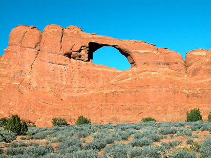
Skyline Arch
Exposure:
SW
Location:
SW of Devils Garden Campground
South Devils Garden
Arches National Park
County:
Grand
7.5 Topo:
Mollie Hogans
Latitude:
N38°46'28.7" (estimated coordinate)
Longitude:
W109°35'22.7" (estimated coordinate)
Other Names:
Arch in the Making, Fallen Rock Arch
Notes:
This arch was called "Arch in the Making" because a large sandstone boulder blocked half of the opening, but fell out in late 1940. The present name comes from its high profile and its visibility from so many points in and out of the Park.
Disclaimer:
All the information on UtahArches.com is published in good faith and for general information purpose only. UtahArches.com does not make any warranties about the completeness, reliability and accuracy of this information. Any action you take upon the information you find on this website (UtahArches.com), is strictly at your own risk. UtahArches.com will not be liable for any losses and/or damages in connection with the use of our website.